
The Maconde viewpoint at Baie du Cap and the south coast road from Chamarel
The Maconde viewpoint is a small lava headland just west of Baie du Cap, where the coast road squeezes round a tight hairpin and about 50 steep steps climb to a platform just above the sea. From Chamarel it is 12.1 km and about 12 minutes by road to Baie du Cap, down the B104 through the hills, and then about 1 km west along the coast. Park on the widened roadside and treat the bend with care, because the viewpoint sits right beside moving traffic.
Read the guide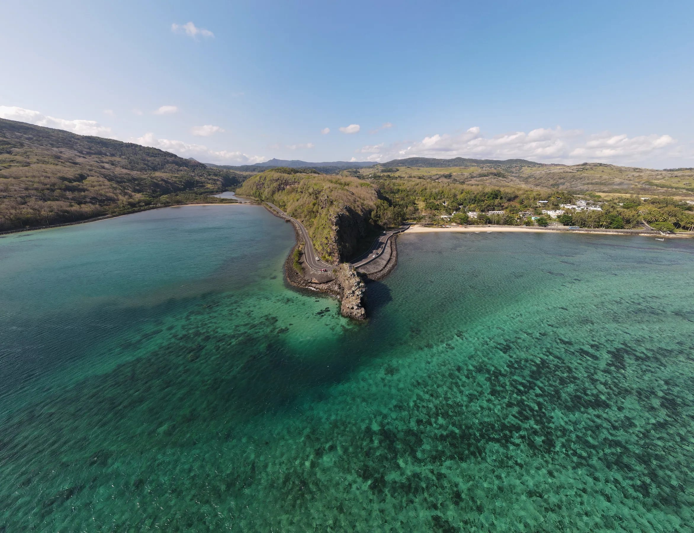
The Maconde viewpoint is a lava rock cut by the coast road
The Maconde viewpoint is a rock spur of solidified lava on the south coast of Mauritius that was cut through to let the coast road pass, leaving a narrow jut of rock and a very tight bend in the road. It is one of the best-known viewpoints in Mauritius, and the improbable tightness of the hairpin only really shows from above.
The Maconde rock stands on the B9 coast road just after Baie du Cap on the way to Le Morne, about 1 km west of the village centre, at 20°29′27.6″S 57°22′16.2″E, roughly -20.4910, 57.3712. The name is written Maconde, Macondé or, in the plural, Macondes.
About 50 steep steps lead to a platform above the sea
A narrow stairway of about 50 fairly steep steps climbs the southern part of the Maconde rock, the part that juts out into the ocean, to a small platform just above the sea.
From the platform you see the south coast, the surrounding coral, the rock itself, the bend in the road and, in the distance, Le Morne Brabant, with a rocky and very broken coastline below. At the top of the stairs stands a district boundary marker dated 1878.
Maconde is a short roadside stop rather than a walk, a few minutes on the steps and the platform, and it can be very crowded.
Where to park safely at the bend
Park on the widened roadside about 50 m from the steps, and never stop on the Maconde hairpin itself, because the viewpoint is small, exposed and close to moving traffic.
There is space right off the road on either side of the rock. Take care when pulling onto the hard shoulder, use the designated stopping area, slow down before blind corners and never stop in the carriageway for a photograph.
- Pull completely off the road before you stop, then walk back to the steps rather than edging the car closer.
- Slow down for the hairpin in both directions, because the bend round the rock is very tight.
- Take extra care after rain, when the hairpins on the descent from Chamarel to Baie du Cap become slippery, especially on the corners.
- Keep children close on the steps and the platform, since the rock juts out into the ocean.
- In an emergency, call 999 for the police (112 also works), 114 for an ambulance or 115 for the fire service. There is a medical dispensary in Baie du Cap village.
The road from Chamarel down to Baie du Cap
The road from Chamarel to Baie du Cap is the B104, 12.1 km and about 12 minutes of driving, running south past the Seven Coloured Earth and down through the hills to the coast.
The water of the Chamarel waterfall reaches the sea at the same village as the Baie du Cap River.
Out of the village
Leave Chamarel on the B104, the Baie du Cap Chamarel Case Noyale Road, the same number as the hairpin climb from Case Noyale. The road passes Curious Mauritius and the entrance of the Chamarel Seven Coloured Earth Geopark.
Through the hills
The road from Chamarel towards Baie du Cap is mountainous, with short, steep climbs and descents, on an excellent surface. Traffic is light early on a Sunday and almost non-existent at 07:00.
Down to the coast
The descent to Baie du Cap winds through hairpin bends that become slippery when wet, especially on the corners, so take them slowly and in a low gear.
Baie du Cap to the rock
At Baie du Cap the road reaches the sea. Follow the B9 coast road west, towards Le Morne, for about 1 km to the Maconde rock and its hairpin.
Getting to Maconde without a car
Maconde can be reached by bus from Baie du Cap, where several routes end, but the bus up to Chamarel has no published timetable, so a taxi or a hire car is the practical choice for most visitors.
Route 5A runs between Baie du Cap and the Sainte-Anne church in Chamarel, and route 5 runs along the coast from Baie du Cap through Le Morne and Rivière Noire to Quatre Bornes. Route 120 links Baie du Cap with Port Louis, and routes 133 and 133A run from Curepipe to Choisy and Baie du Cap, about every 30 minutes. Rural buses run roughly from 06:30 to 18:30, and fares are paid to the conductor.
From Baie du Cap village, the Maconde rock is about 1 km west along the coast road. Anyone walking it shares the very tight bend with traffic, so take great care on foot, and agree any taxi fare before you set off, because Mauritian taxis have no fixed tariff.
Where the name Maconde comes from is disputed
Nobody has settled where the name Maconde comes from, and the two explanations in circulation disagree.
One traces the name to enslaved people from Africa and Mozambique who occupied the area, and to the “Mat Condé”, a group of enslaved people known for their high hairstyles. The other names a governor, Jean-Baptiste Henri Condé, as the man who laid out a viewpoint here. No primary source supports either explanation.
The road has a clearer story. The coast road round Mauritius long broke off at Baie du Cap, because the mountain was too hard to get around, until a way was cut through. The 1920s is the date usually given for the cutting, and no primary record stands behind it.
Baie du Cap and the coast road beyond it
Baie du Cap is a small village where the B104 from Chamarel meets the sea, and from there the B9 coast road runs west past Maconde to Le Morne and east towards Bel Ombre.
Westward, the coast road passes Maconde and La Prairie, which gives one of the clearest ground-level views back to Le Morne, and reaches Le Morne after about 7 km along the sea. From Le Morne, the drive back up to Chamarel through La Gaulette and Case Noyale closes the loop.
Eastward, the B9 continues through Saint Martin and Bel Ombre towards the beaches of St Félix, Riambel and Gris Gris. This guide stops at Baie du Cap.
Chamarel has no cash machine, but Baie du Cap has MCB cash machines open 24 hours, which makes it the place to draw cash on this side of the hill.
Questions people ask
Where is the Maconde viewpoint?
The Maconde viewpoint is on the B9 coast road just after Baie du Cap on the way to Le Morne, about 1 km west of the village centre, at roughly -20.4910, 57.3712. From Chamarel, take the B104 south to Baie du Cap, 12.1 km and about 12 minutes of driving, then follow the coast road west to the rock and its hairpin bend.
Is there parking at the Maconde viewpoint?
Parking at the Maconde viewpoint is on the roadside rather than in a car park. There is a widened stretch of roadside about 50 m from the steps, and space right off the road on either side of the rock. Pull completely off the carriageway, never stop on the hairpin, and walk back to the stairs.
How many steps are there at Maconde?
The Maconde staircase has about 50 steep, narrow steps, and it climbs the southern part of the rock to a small platform just above the sea. At the top stands a district boundary marker dated 1878. The climb is short, but keep children close because the rock juts out into the ocean.
How long is the drive from Chamarel to Maconde?
The drive from Chamarel to Baie du Cap is 12.1 km and about 12 minutes of driving, and the Maconde rock is about 1 km further west along the coast road. Allow longer than that, because the B104 is mountainous and its hairpins down to Baie du Cap become slippery when wet, especially on the corners.
Why is it called Maconde?
The origin of the name Maconde is disputed. One explanation links it to enslaved people from Mozambique and to the “Mat Condé”, a group known for their high hairstyles, and the other credits a governor named Jean-Baptiste Henri Condé with laying out a viewpoint there. No primary source settles the question.
Can I combine Maconde with Le Morne and Chamarel?
Maconde fits neatly into a loop from Chamarel. Drive down the B104 to Baie du Cap, stop at the rock, continue west past La Prairie to Le Morne, about 7 km from Baie du Cap along the sea, and return to Chamarel through La Gaulette and Case Noyale. Le Morne to Chamarel is 13.9 km and about 18 minutes by road.
Make it a loop via Le Morne
The Chamarel and Le Morne page explains how to fit the hill, the mountain and the lagoon into the same day.